Quakefinder Blog

The Race to Forecast Earthquakes
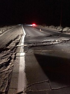
Road Damage due to the M7.1 Earthquake in Southern California on July 5, 2019

California State Route 178 SW of Trona, following the M7.1 earthquake. Road is now closed for repairs (USGS/Public domain).

Earthquakes dominated the headlines for three days straight recently, with a 6.9 magnitude quake in the Molucca Sea near Indonesia triggering a tsunami warning on July 6. On July 5, as reported by the United States Geological Survey (USGS), a magnitude 7.1 earthquake struck southern California just one day after a magnitude 6.4 earthquake hit the same area.
 
At this time, no organization anywhere has the ability to predict the exact time or location of earthquakes or their aftershocks. The events in California were the region’s most powerful earthquakes in over two decades, made even more notable by the size of the foreshock and the aftershocks which have numbered in the thousands. And their impact could continue for months and years.
 
Just as society once lacked adequate preparedness for frequent and severe threats like hurricanes, floods, and tornadoes, earthquake-prone areas of the world like California could benefit significantly from predictive technologies. Stellar Solutions is responding to this grand challenge through the humanitarian R&D initiative, QuakeFinder. Historically, earthquake forecasting research has focused on seismic data, but our team is pursuing indications that electromagnetic data can contain earthquake precursors. QuakeFinder’s international array of 170 terrestrial sensors is collecting high-resolution magnetic field data that enables research of short-term, accurate earthquake forecasting to reduce trauma, death, and damage.
 
The QuakeFinder team has taken an initial look at the data from its sensors about 40 miles from this earthquake cluster southwest of Searles Valley. We discovered that the QuakeFinder station in California City shows a marked increase in magnetic activity starting 12 days before the July 5 earthquake. This is just the beginning of a lengthy research process that will require in-depth analysis of data collected locally over the months and years prior to the quakes. A review of the two most recent years of data at this station indicated several other instances of comparable activity that were not associated with earthquakes, so the team will conduct further reviews to rule out contamination from cultural sources, lightning storms, and increased solar activity as possible causes.
 
Luckily, there were no serious injuries reported from these recent earthquakes throughout the remote region near Ridgecrest in California, although very strong tremors and property damage took place. Due to the sparsely populated area, the USGS economic impact assessment of these quakes is currently a “yellow” (from tens to hundreds of millions of dollars). It could have been much worse (“red” alert with impact of $1 billion or more) had the earthquakes struck in the heart of the Los Angeles Basin. The substantial danger to life, infrastructure, and the economy was vividly illustrated by the 1989 magnitude 6.9 ‘Loma Prieta’ Earthquake that struck populous northern California, killing 63 people and injuring nearly four thousand, with over $6 billion in economic losses. Inspired to action by this devastating event, QuakeFinder founder Tom Bleier devised the innovative idea of placing sensors to capture pre-seismic underground electromagnetic disturbances.
 
Over forty years ago, earthquake prediction was recognized by the National Research Council of the National Academies as a technology capability in its infancy that could support major public policy issues and ultimately save lives in California, across the country and beyond. Their report stated, “…our analyses indicate that constructive use of the period of advance warning will depend largely on wholehearted participation and leadership from the private sector. Many of the most troublesome prospects in the economic sphere can be dealt with effectively only through cooperative planning by leaders of business. finance, and labor working together with government officials.”
 
Stellar leadership recognizes that scientific change can be difficult, and this is where industry-led collaborative efforts like QuakeFinder are playing a key role. QuakeFinder relies on funding and contributions from industry and university partners to continue research, expand the array, improve instrumentation, and refine the algorithms to provide advance notice of earthquakes in the days or weeks prior.
 
QuakeFinder has collected data continuously since 2005 through a worldwide network larger than any we can confirm. During this time, our stations have observed thousands of small earthquakes and more than 200 medium-sized earthquakes (magnitude 4 or greater) which is dozens of times larger than prior published non-seismic forecasting research. Stellar Solutions has invested $30-million in this effort, which was recently the basis of a proposal selected by the National Geospatial-Intelligence Agency to move forward in a competition to advance the World Magnetic Map.